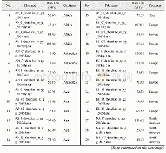
《Table 5 Data files of the“Global multiple scale shorelines dataset based on Google Earth images(201
 提示:宽带有限、当前游客访问压缩模式
本系列图表出处文件名:随高清版一同展现
《2015年全球岛(礁)有多少陆地面积及海岸线长几何——基于Google Earth遥感影像的数据结果》
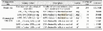
In addition to the spatial data with meters resolution for continental mainland and islands(isles,rocks),the data also include the corresponding attribute data(Table 6).The attribute data include the codes for each island(isle,rock)including the code in each data file,the code in each continent,and the code in the global islands(isles,rocks),the shoreline length in the Lambert projection,and the area in the Albers projection.Using the Hawaiian Island of the United States as an example(Figure 19),data of the Island are archived in the data file of OA_I2_shoreline_m_gg_2015 in the.kmz and.shp formats.The attributes of the Island include the code of the Island in the data file of OA_I2_shoreline_m_gg_2015 as 7,998,the area as10,432,046,089 m2,the shoreline length as 821,973m,its affiliation as in Oceania,the code in Oceania as 24,882,the code in the world as 604,138,and its classification as class C as its area being between10,000 and 100,000 km2(Table 2).
| 图表编号 | XD00110314100 严禁用于非法目的 |
|---|---|
| 绘制时间 | 2019.06.25 |
| 作者 | 刘闯、石瑞香、张应华、申艳、马军花、吴立宗、陈文波、Tomoko Doko、陈利军、吕婷婷、陶醉、诸云强 |
| 绘制单位 | 中国科学院地理科学与资源研究所、中国科学院地理科学与资源研究所、中国科学院地理科学与资源研究所、中国科学院地理科学与资源研究所、中国科学院地理科学与资源研究所、中国极地研究中心、日本庆应义塾大学SFC研究所、日本自然与科学咨询公司、日本庆应义塾大学SFC研究所、日本自然与科学咨询公司、国家基础地理信息中心、中国科学院空天信息研究院、中国科学院空天信息研究院、中国科学院地理科学与资源研究所 |
| 更多格式 | 高清、无水印(增值服务) |