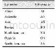
《Table 3 Continent abbrevia-tion in the data file》
 提示:宽带有限、当前游客访问压缩模式
本系列图表出处文件名:随高清版一同展现
《2015年全球岛(礁)有多少陆地面积及海岸线长几何——基于Google Earth遥感影像的数据结果》
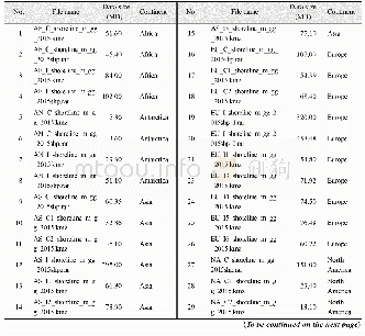
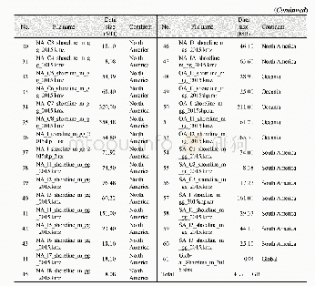
The name of the data file briefly describes the main attributes of the data.The file was named in a six-segment way,i.e.,continent_mainland/island_shoreline_spatial resolution_projection_year.There are two types for the second seg-ment:C is for the mainland and I is for island.The meters resolution is expressed as m,the geographic coordinate system is expressed as gg,and the year is 2015.For example,SA_C_shoreline_m_gg_2015 is the shoreline data in2015 with meters resolution and geographic coordinate system for the mainland of South America,and SA_I_shoreline_m_gg_2015 is the shoreline data in 2015with meters resolution and geographic coordinate system for the islands(isles,rocks)of South America.The corresponding abbreviations are AF for Africa,OA for Oceania,NA for North America,EU for Europe,AS for Asia,and AN for Antarctica(Table 3).
| 图表编号 | XD00110312200 严禁用于非法目的 |
|---|---|
| 绘制时间 | 2019.06.25 |
| 作者 | 刘闯、石瑞香、张应华、申艳、马军花、吴立宗、陈文波、Tomoko Doko、陈利军、吕婷婷、陶醉、诸云强 |
| 绘制单位 | 中国科学院地理科学与资源研究所、中国科学院地理科学与资源研究所、中国科学院地理科学与资源研究所、中国科学院地理科学与资源研究所、中国科学院地理科学与资源研究所、中国极地研究中心、日本庆应义塾大学SFC研究所、日本自然与科学咨询公司、日本庆应义塾大学SFC研究所、日本自然与科学咨询公司、国家基础地理信息中心、中国科学院空天信息研究院、中国科学院空天信息研究院、中国科学院地理科学与资源研究所 |
| 更多格式 | 高清、无水印(增值服务) |