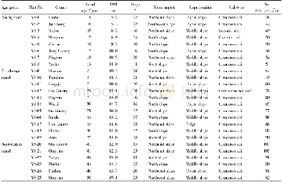
《Table 1 Forest inventory data of New England States along eastern coast gradients》
 提示:宽带有限、当前游客访问压缩模式
本系列图表出处文件名:随高清版一同展现
《"Forest biodiversity, relationships to structural and functional attributes, and stability in New England forests"》
New England refers to a region of six states in the northeastern corner of the Unite States.From north to south it includes Maine,New Hampshire,Vermont,Massachusetts,Rhode Island and Connecticut.Topographically,the western regions of New England are mountainous,running from north to south as part of Appalachian Mountains range,and the eastern regions are coastal areas facing the Atlantic Ocean(Fig.1a).These geographical features affect climate patterns within New England,which is generally colder and drier in the northwest,warmer and wetter in the southeast(Fig.1b and c).The US Forest Service forest inventory and analysis data(FIA)at tree/plot levels were derived from the national database for New England states between latitudes 41°05′N and 47°26′N(Table 1).We used the most recently collected data(2011–2016)from FIA Phase 2 and Phase 3 plots(https://www.fia.fs.fed.us/li brary/database-documentation/index.php).The Forest Service FIA program has established more than 300,000permanently plots nationwide and measured millions of trees in the plots with detailed records.Each plot contains 4 subplots and represents a combined sampling area of~672.5 m2spread out across~0.4 ha(or 1-acre)(Anonymous 2017).For the New England states,the data used for this study come from 6096 inventory plots and 334,057 individual trees(Table 1).The variables we selected and processed for this study include plot data of forest age,height and living biomass,and individual tree data of each species in each plot,including DBH and basal area.These plot and individual tree data provide necessary information for examining forest structure,function,and tree species diversity.
| 图表编号 | XD003826200 严禁用于非法目的 |
|---|---|
| 绘制时间 | 2018.06.01 |
| 作者 | Yude Pan、Kevin McCullough、David Y. Hollinger |
| 绘制单位 | USDA Forest Service、USDA Forest Service、USDA Forest Service |
| 更多格式 | 高清、无水印(增值服务) |


