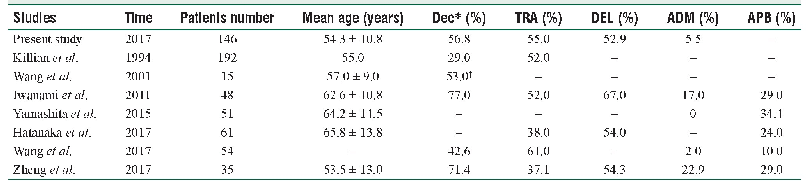
《Table 2 The distribution of 137Cs inventory on cultivated land slopes》
 提示:宽带有限、当前游客访问压缩模式
本系列图表出处文件名:随高清版一同展现
《The features of soil erosion and soil leakage in karst peak-cluster areas of Southwest China》
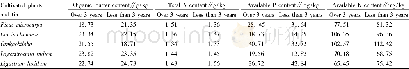
By tests and calculation,the local reference137Cs inventory is 141.59 m Bq/cm2 in 2010 and138.37 m Bq/cm2 in 2011 respectively.Table 2 and Fig.4 show that the 137Cs inventory ranging from7.51 to 113.99 m Bq/cm2 and the loss ratio of inventory compared with the reference figures of17.62%to 94.7%on the slope before correction,indicates great variation.What’s more,the loss ratio of the peak slope position is only 17.62%before correction,which is not consistent with the conditions of high bare rock ratio,few soil,and severe soil and water loss before treatment.However,the 137Cs inventory ranged from 2.02 to47.09 m Bq/cm2 and the loss ratio of inventory ranged from 66.75%to 98.57%on the slope after correction.Corrected data are more in line with the status quo of serious rocky desertification and mass soil loss of the slope.Both before and after correction,for peak slope to depression,the 137Cs inventoriy of slope decreases first and then increases,while the loss ratios increases first and then decreases correspondingly.Among Different geomorphologic locations,137Cs inventory of depression is the highest,the second is of pass area,and the lowest is of steep slope.According to the loss ratios of different geomorphologic locations,if ranked from the highest to the lowest,they are steep slope,gentle slope,peak slope,pass area,foot slope and depression respectively.Except peak slope and pass area,from steep slope to depression,the inventories increase gradually,but the loss ratios reduce gradually down the slope.Except peak slope,all the 137CS loss ratios of cultivated land with strong artificial disturbance exceeded 60%.The maximum 137CS loss ratios of steep slope more than 25°reached 98.57%,which demonstrates severe surface soil erosion.For shrub-grass land with less human disturbance on peak slopes,its condition was totally different before 2003.Serious rocky desertification,high slope degree,a lot of surface fissures and karst caves,7.37%soil coverage rate only,so plenty of soil loss along the slope and through epikarst fractures had resulted in relatively large 137CS loss ratio of 93.93%.After adopting treatment measures such as closing hillsides to facilitate afforestation in 2003,soil loss of peak slopes has gradually reduced year by year,which led to lower 137CS loss ratio of the shrub-grass land on peak slopes than that of cultivated land on both steep slopes and gentle slopes.
| 图表编号 | XD0016466500 严禁用于非法目的 |
|---|---|
| 绘制时间 | 2018.03.01 |
| 作者 | LUO Wei-qun、JIANG Zhong-cheng、YANG Qi-yong、LI Yan-qing、LIANG Jian-hong |
| 绘制单位 | Institute of Karst Geology,CAGS、Key Laboratory of Karst Ecosystem and Rocky Desertification, Ministry of Land Resources、Institute of Karst Geology,CAGS、Key Laboratory of Karst Ecosystem and Rocky Desertification, Ministry of Land Resources、Key Laboratory |
| 更多格式 | 高清、无水印(增值服务) |
