《Table 2 Statistics of Yalu River and its branches》
 提示:宽带有限、当前游客访问压缩模式
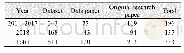
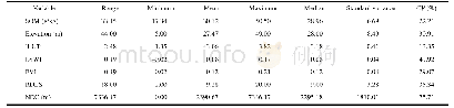
The Yalu drainage basin locates between the Tumen River Basin,Songhua River Basin in north and the West Korea Bay in south;the Liao River Basin in west and the Taedong-gang River basin in east,its geolocation is from 39°43′57″N to 42°17′28″N,123°35′59″E to128°45′50″E.It covers an area of 65,215.49 km2,in which,32,799.22 km2is in China and32,416.27 km2in North Korea.The boundary of the Yalu basin in China part is from the southern slope of Changbai Mountain to Changbai Mountain range in southwest,and to the northern part of Qian Mountain Range,and then go to south to the West Korea Bay;in North Korea part,the boundary from the Changbai Moutain to Motianling Mountain in the southeast,then turn to southwest in Mt.Touliu(23.9 m)to Pujon Mt.range,and then turn to west from Yongung-Ri to Mt.Lunglin(2,148 m),Kwangsong,Songwon,again,turn to southwest to Mt.Diyuling,Mt.Jiangnan to West Korea Bay.The Yalu River rises in southern slope of Tianchi Lake of Mt.Changbai and meets the Yellow Sea at the West Korea Bay,it is 844.98km long.Its tributaries include Hochon,Changjin,Houzhou,Cicheng,Tongro,Zhongman,and Sanqiao Rivers in P.R.Korea;Hun,Pushi,and Ai Rivers in China.It covers areas of Chang Bai Man Aoton County,Linjiang City,Jian City,Huairen Man County,Kuandian Man County,Dandong City and Donggang City in China and Ryanggang,Chagang and North Pyongan Provinces in North Korea.Because of the temperature monsoon weather(the annual rain fall is 800-1,200 mm)and the steep slope of mountain land,the high gradient reaches 3.2‰,and even 10‰in some region.More reservoirs were constructed along the river,they are:Shuifeng R.(China and North Korea),Yunfeng R.(China and North Korea),Wiwon R.(China and North Korea),Tiejia R.(China),Huanren R.(China),Huilongshan R.(China),Manfeng-Ho(North Korea),Songwon R.(North Korea),Sijung-Ho(North Korea),Rangrim-Ho(North Korea),Changjin-Ho(North Korea),Fuzhan-Ho(North Korea),Phungso-Ho(North Korea)and Hochon River R.(North Korea).The dataset including the Yalu River and its basin in.kmz and.shp data formats,the data size is 43.8 MB(20.1 MB in compressed).
| 图表编号 | XD0027629100 严禁用于非法目的 |
|---|---|
| 绘制时间 | 2017.12.25 |
| 作者 | 刘闯、石瑞香、郝蒙蒙 |
| 绘制单位 | 中国科学院地理科学与资源研究所、中国科学院地理科学与资源研究所、中国科学院地理科学与资源研究所、中国科学院大学 |
| 更多格式 | 高清、无水印(增值服务) |


