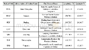
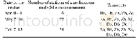
《Table 1 Longitude and latitude of 21 CERN ecological stations》
 提示:宽带有限、当前游客访问压缩模式
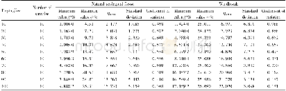
This dataset is the collection of phenological datasets from 21 CERN ecological stations of CERN(Ailao Moutain,Beijing Forest,Cele,Changbai Moutain,Dinghu Moutain,Ordos,Fukang,Gongga Moutain,Haibei,Heshan,Huitong,Linze,Maoxian,Naiman,Inner Mongolia,Puding,Qingyuan,Sanjiang,Shapotou,Shennongjia,Xishuangbanna)that have been recording plant phenological observations since 2003(Figure 1 presents the location information.Table 1 presents the longitude and latitude).
| 图表编号 | XD0027540100 严禁用于非法目的 |
|---|---|
| 绘制时间 | 2017.03.01 |
| 作者 | 宋创业、张琳、吴冬秀、白帆、冯静、冯丽、杜明武、杜娟、戴冠华、李向义、李以康、李原理、刘世忠、倪建、冉飞、饶兴权、唐建维、王小亮、温韩东、颜绍馗、于立忠、张新厚、赵常明、周志琼 |
| 绘制单位 | 中国科学院植物研究所、中国科学院植物研究所、中国科学院植物研究所、中国科学院成都生物研究所 |
| 更多格式 | 高清、无水印(增值服务) |
