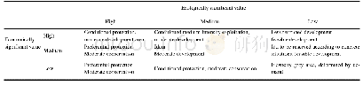
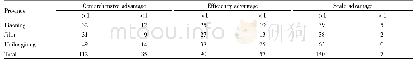
《Table 2 Matrix classification of ecological-economic value and development regulation》
 提示:宽带有限、当前游客访问压缩模式
本系列图表出处文件名:随高清版一同展现
《"Spatial Function Regionalization Based on an Ecological-economic Analysis in Wuxi City, China"》
In the early 19th century,geographers began to attempt regionalization based on their cognition of natural tokens.German geographer Humboldt’s Isotherm Table,Russian geographer Dokuchaev’s Soil Belt Theory and Hommever’s Four-grade Geographical Units Theory initiated the research on the spatial regionalization of land use(Wu et al.,2003).Based on natural and economic elements,some researchers studied spatial function regionalization to guide land use and space control.As early as the 1920s,the United States initiated startedland-use zoning,stipulating the scope of zoning,types of utilization and permitted maximums of exploitation and in the 1960s,issued a series of regulations to ensure the implementation of land-use zoning(Baics and Meisterlin,2016;Lin et al.,2016).Land carrying capacity could be assessed with potentially restrictive elements,thereby categorizing the assessed land into four types of environmentally sensitive zones that are ecologically critical areas in perpetuity(Knaap,2001).McHarg(1997)denoted the natural and economic attributes of a research area on a map and divided the development subarea using a map overlay.A Sino-German joint project,the Jiangning Nanjing Project,proposed the notion of a matrix classification of ecological conservation value versus economic and social development,which was quite conducive to making overall plans for land use in terms of both the environment and the economy.
| 图表编号 | XD0046964300 严禁用于非法目的 |
|---|---|
| 绘制时间 | 2019.04.01 |
| 作者 | SUN Wei、CHEN Wen、JIN Zhifeng |
| 绘制单位 | Nanjing Institute of Geography & Limnology, Chinese Academy of Sciences、Key Laboratory of Watershed Geographic Sciences, Chinese Academy of Sciences、Nanjing Institute of Geography & Limnology, Chinese Academy of Sciences、Key Laboratory of Watershed Geogra |
| 更多格式 | 高清、无水印(增值服务) |