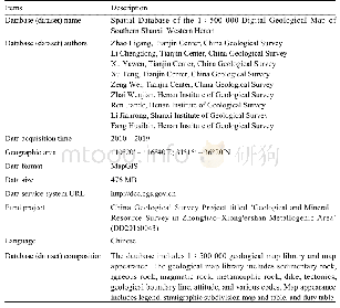
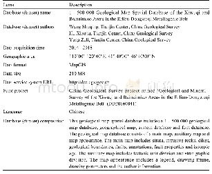
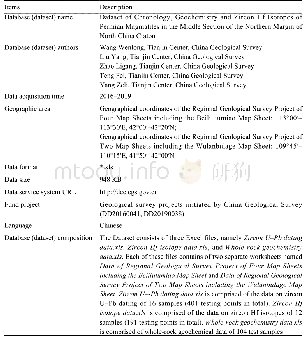
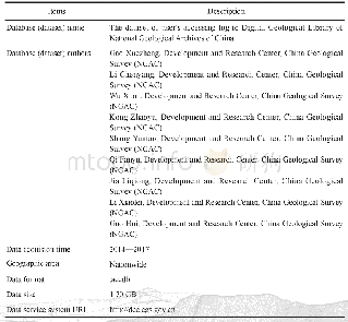
《Table 1 Metadata Table of Database (Dataset)》
 提示:宽带有限、当前游客访问压缩模式
本系列图表出处文件名:随高清版一同展现
《河北省古冶幅、唐山幅、范各庄煤矿幅1:50000地质图空间数据库》
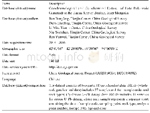
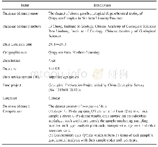
This regional geological survey applied a combination of various working methods including field route geological survey,field measured profile,remote sensing interpretation,geophysical exploration,drilling and sample testing for effective data acquisition.The 1∶50 000 regional geological survey was carried out in line with the requirements of the‘1∶50 000 Regional Survey Project Task Book of Guye Map-sheet,Tangshan Map-sheet,and Fangezhuangmeikuang Map-sheet’,and in conformity with the‘General Provisions for Regional Geological Survey (1∶50 000)’(DZ/T 0002-1991),and‘Guidelines for 1∶50 000Regional Geological Survey (Trial)’.All kinds of basic data acquisition were completed according to the project workload design (Table 2).
| 图表编号 | XD00219951500 严禁用于非法目的 |
|---|---|
| 绘制时间 | 2020.06.01 |
| 作者 | 赵保强、张兆祎、王克冰、王川、徐永利、耿晓磊 |
| 绘制单位 | 河北省地质调查院、河北省地质调查院、河北省地质调查院、河北省地质调查院、河北省地质调查院、河北省地质调查院 |
| 更多格式 | 高清、无水印(增值服务) |