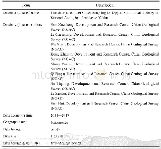
《Table 1 Metadata Table of Database(Dataset)》
 提示:宽带有限、当前游客访问压缩模式
本系列图表出处文件名:随高清版一同展现
《新型小城镇地质环境综合调查服务——以江苏丹阳2016年数据集为例》
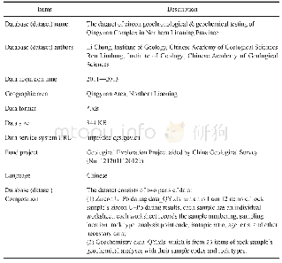
As a pilot geological survey to serve new urbanism,the comprehensive geological environment survey involved complete work and diverse methods.Therefore,a large amount of data was collected by the comprehensive application of remote sensing,ground investigation,geophysical prospecting,drilling,various in-situ tests and indoor tests of water and soil samples.During the comprehensive survey and mapping of the Quaternary geology,hydrogeology and engineering geology at a scale of 1∶50 000,thematic research was conducted targeting the demand for urbanism.The comprehensive geological environmental survey was designed and deployed in accordance with the Technical Requirement for Environmental Geological Survey(1∶50 000),and all operations and tests during the survey were carried out strictly in accordance with applicable specifications or technical instructions on drilling,sampling and testing.The workload of the comprehensive survey involves the interpretation of remote sensing images covering an area of 1 047 km2(including data from three phases),767 survey points,115 boreholes,accumulated footage of 8 720 m(including915 m for the Quaternary boreholes,2 366 m for hydrological boreholes,and 5 439 m for engineering geological boreholes),2 904 Quaternary geological samples,240 groundwater samples,1 108 undisturbed earth samples,2 482 groups of soil samples,70 points for simultaneous measurement of groundwater levels and 18 pumping tests.
| 图表编号 | XD00149447000 严禁用于非法目的 |
|---|---|
| 绘制时间 | 2019.12.01 |
| 作者 | 葛伟亚、常晓军、贾军元、雷廷、邢怀学、周洁、余成、田福金、李亮 |
| 绘制单位 | 中国地质调查局南京地质调查中心、中国地质调查局南京地质调查中心、中国地质调查局南京地质调查中心、中国地质调查局南京地质调查中心、中国地质调查局南京地质调查中心、中国地质调查局南京地质调查中心、中国地质调查局南京地质调查中心、中国地质调查局南京地质调查中心、中国地质调查局南京地质调查中心 |
| 更多格式 | 高清、无水印(增值服务) |