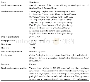
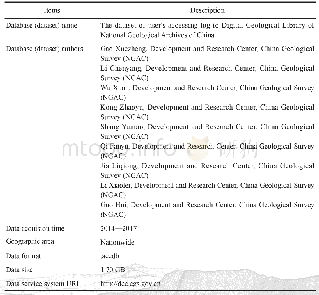
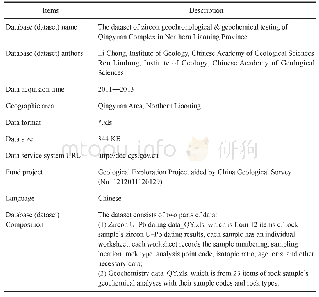
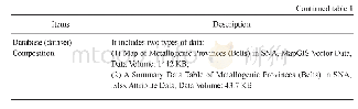
《Table 1 Metadata Table of Database (Dataset)》
 提示:宽带有限、当前游客访问压缩模式
本系列图表出处文件名:随高清版一同展现
《晋南–豫西地区1:500000数字地质图空间数据库》
To compile the 1∶500 000 digital geological map spatial database of the southern Shanxi–western Henan region (Table 1,Zhao LG et al.,2020),we consulted the results of the 1∶500 000 and 1∶250 000 regional geological surveys in recent years,and conducted a geological profile survey and systematic sampling of key strata and magmatic rock;and in the process,redating some key strata.For example,through the LA-MC-ICPMS zircon U–Pb dating of the tuff of the Luoyukou Formation in the Luoyu Group,the ages that were obtained were 1 634±10 Ma and 1 638±8.8 Ma,thus classifying it into the Changcheng System (Li CD et al.,2017),initially establishing the middle–upper Proterozoic stratigraphic correlation framework in this area.The original Guishan Formation was determined as a subduction–accretionary complex within the Eastern Qinling orogenic belt,which is composed of Neoproterozoic and early Palaeozoic rock blocks and matrices,which signifies that the eastern extension of the Shangdan Subduction Belt was formed in the early Palaeozoic (Chang QS et al.,2018;Li CD et al.,2019);the Zimugou Formation is not a stratigraphic unit,but is in actual fact a subduction mélange in the Zhuxia Subduction Belt and was categorized into different eras.Therefore,a new scheme for the structure and evolution of the Eastern Qinling orogenic belt was proposed.Based on the isotopic chronological data from publications and regional geological survey work in recent years,the era of the magmatic rocks in the region was updated.
| 图表编号 | XD00219946300 严禁用于非法目的 |
|---|---|
| 绘制时间 | 2020.06.01 |
| 作者 | 赵利刚、李承东、许雅雯、许腾、曾威、孙烜烨 |
| 绘制单位 | 中国地质调查局天津地质调查中心、中国地质调查局天津地质调查中心、中国地质调查局天津地质调查中心、中国地质调查局天津地质调查中心、中国地质调查局天津地质调查中心、中国地质调查局天津地质调查中心 |
| 更多格式 | 高清、无水印(增值服务) |