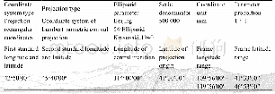
《Table 2 Topographical Map Involved in 1:10, 000 Fengjie Mapsheet》
 提示:宽带有限、当前游客访问压缩模式
When 1:10,000 topographic map was used in ArcGIS(ArcToolBox>Data Management Tools>Projections and Transformations Tools),the data whose central meridian was 108in Row A should be projected and transformed into the central meridian of 111.Then,20 maps involved were pieced together.By virtue of ArcGIS,high precision DEM and mountain shade were generated,which acted as the background base map.
| 图表编号 | XD00191988000 严禁用于非法目的 |
|---|---|
| 绘制时间 | 2018.09.01 |
| 作者 | 李刚、杨秀元、李浩、乐琪浪 |
| 绘制单位 | 中国地质调查局水文地质环境地质调查中心、中国地质调查局水文地质环境地质调查中心、中国地质调查局水文地质环境地质调查中心、中国地质调查局水文地质环境地质调查中心 |
| 更多格式 | 高清、无水印(增值服务) |
