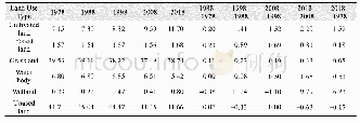
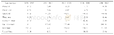
《Tab.2 The area of land use types from 1980to 2018in Kuye River Basin》
 提示:宽带有限、当前游客访问压缩模式
km2
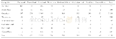
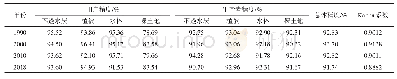
From the perspective of spatial pattern:The farmland was mainly distributed in the low-lying southeast and less in the northwest of the study area;The residential land concentrated in the west-north at a high elevation;The coal mine land was mainly distributed in the central and northern parts of the study area and had sparse distribution in the southeast,and it was overall distributed near two tributaries of the Ulan Moron River and the Beiniuchuan River;The sand land and unused land concentrated in the central and northwestern regions.
| 图表编号 | XD00152758900 严禁用于非法目的 |
|---|---|
| 绘制时间 | 2020.08.25 |
| 作者 | 蒋晓辉、高昊祺、雷宇昕 |
| 绘制单位 | 西北大学陕西省地表系统与资源环境承载力重点实验室、西北大学城市与环境学院、西北大学陕西省地表系统与资源环境承载力重点实验室、西北大学城市与环境学院、西北大学陕西省地表系统与资源环境承载力重点实验室、西北大学城市与环境学院 |
| 更多格式 | 高清、无水印(增值服务) |
