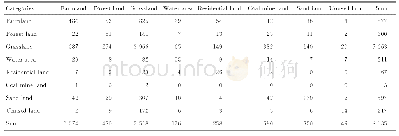
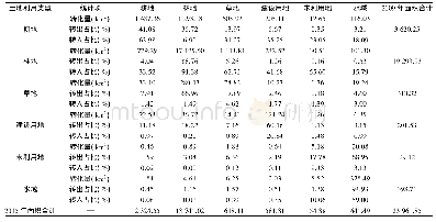
《Tab.3 Dynamic transfer matrix of land use during 1980-2018in Kuye River Basin》
 提示:宽带有限、当前游客访问压缩模式
km2
Through comparison,it can be found that over the last 40years,the area of farmland in this area declined considerably,and the area of forest land increased significantly.Meanwhile,51%of sand land and 79%of unused land converted to grassland.It shows that the measures such as large-scale afforestation and grass planting as well as returning the grain plots to forestry promoted in this area achieved good results.Plenty of sand land and unused land were used for ecological construction,which resulted in an increase in the vegetation coverage and improvement of the overall ecological environment in this area.This phenomenon was basically consistent with the research result of Wang et al.[12]in 2017.But at the same time,the coal mining was expanding.The annual exploitation quantity increased from 900 000tons in 1980to 225million tons in 2017with an increase of nearly 250times.Meanwhile,the mine area evidently expanded,the growth rate of which even reached to 192 33%.The effect of this situation on the environment could not be ignored.
| 图表编号 | XD00152759100 严禁用于非法目的 |
|---|---|
| 绘制时间 | 2020.08.25 |
| 作者 | 蒋晓辉、高昊祺、雷宇昕 |
| 绘制单位 | 西北大学陕西省地表系统与资源环境承载力重点实验室、西北大学城市与环境学院、西北大学陕西省地表系统与资源环境承载力重点实验室、西北大学城市与环境学院、西北大学陕西省地表系统与资源环境承载力重点实验室、西北大学城市与环境学院 |
| 更多格式 | 高清、无水印(增值服务) |