《Table 6 Table of Shallow Well Record》
 提示:宽带有限、当前游客访问压缩模式
本系列图表出处文件名:随高清版一同展现
《粤港澳湾区1:50000斗门镇幅工程地质调查及岩土样品试验数据集》
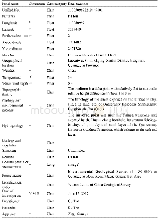
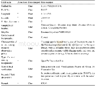
The data from the engineering geological field survey are presented in the table of shallow well record and table of weathering degree of rocks survey.The table of shallow well record(Table 6)includes:Unified No.,Field No.,Longitude,Latitude,Surface elevation,X coordinate,Y coordinate,Map No.,Geographical location,Weather,Temperature,Water level depth,Topographic feature,Geology and environmental geology,Hydrogeology,Ecology and vegetation,Sampling,Remark,Column profile of shallow well,Project name,Investigation entity,Date of investigation,Investigator,Recorder,Approver,etc.The table of weathering degree of rocks survey includes:Unified No.,Field No.,Longitude,Latitude,X coordinate,Y coordinate,Geographical location,Surface elevation,Map No.,Weather,Temperature,Investigation method,Topographical gradient,Overburden thickness,Photo No.,Age of bedrock,Lithology of bedrock,Spatial distribution,Classification of rock strength,Construction relation,Dip direction of rock formation,Dip angle of rock formation,Classification of weathering degree of rocks,Thickness of weathered rock layer,Morphology of weathered rock layer,Properties of weathered rock layer,Fissure,Plan sketch,Profile sketch,Remark,Project name,Investigation entity,Date of investigation,Investigator,Recorder,Approver,etc.
| 图表编号 | XD00149450500 严禁用于非法目的 |
|---|---|
| 绘制时间 | 2019.12.01 |
| 作者 | 曾敏、赵信文、喻望、顾涛 |
| 绘制单位 | 中国地质调查局武汉地质调查中心、中国地质调查局武汉地质调查中心、中国地质调查局武汉地质调查中心、中国地质调查局武汉地质调查中心 |
| 更多格式 | 高清、无水印(增值服务) |


