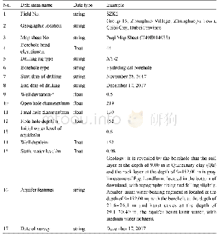
《Table 6 Structure of“Basic information of boreholes.xlsx”》
 提示:宽带有限、当前游客访问压缩模式
本系列图表出处文件名:随高清版一同展现
《湖北省蒲圻县(赤壁)幅1:50000环境地质调查数据集》
The quality control of various survey points followed Technical Requirement for Environmental Geological Survey(1∶50 000)(DD 2019–07),Specification for Hydrogeological Survey(1∶50 000)(DZ/T 0282–2015)and Standard Guide for Karst Collapse Investigation(1∶50 000)(the version for approval).The Beijing Geodetic Coordinate System 1954 was adopted.The coordinates of the survey points were determined with a portable GPS device and are consistent with the information of surface features and the data in topographical maps.The collation of the data of survey points includes data filling and checking in the field,indoor check of the data and data verification during the input of data into the database.A three-level quality inspection system was adopted for checks and the procedures of self-check,mutual check and spot check were performed.
| 图表编号 | XD00149439700 严禁用于非法目的 |
|---|---|
| 绘制时间 | 2019.12.01 |
| 作者 | 张傲、邵长生、王岑、杨艳林、路韬 |
| 绘制单位 | 中国地质调查局武汉地质调查中心、中国地质调查局武汉地质调查中心、中国地质调查局武汉地质调查中心、中国地质调查局武汉地质调查中心、中国地质调查局武汉地质调查中心 |
| 更多格式 | 高清、无水印(增值服务) |
![Table 3 Validation of neighborhood structure[14]](http://bookimg.mtoou.info/tubiao/gif/QQSJ201903009_05500.gif)

