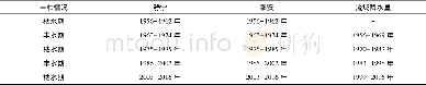
《Table 2 Comparison of spatial scope at the same scale》
 提示:宽带有限、当前游客访问压缩模式
本系列图表出处文件名:随高清版一同展现
《Reflections and Explorations on the Decremented Regulation of Construction Land in the New Beijing City Master Planning》
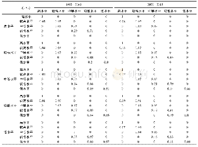
The area of the central urban area of Beijing is about 1,378 km2 with a spatial radius of 20–30 km,similar to the size of an international metropolis.This area has been densely distributed with super high-rise buildings and the construction density is 2.4–2.6 times to that of Grand London and Tokyo,which brings along the high-density concentration of population.At present the density of permanent residence population is 9,300 per km2,slightly higher than Grand Paris and around 1.5–1.7 times to that of Tokyo and Grand London(see Table 3).
| 图表编号 | XD0012620000 严禁用于非法目的 |
|---|---|
| 绘制时间 | 2018.06.01 |
| 作者 | Chang Qing、Xu Qinzheng、Yang Chun、Wang Shan、Qian Fang |
| 绘制单位 | Department of Detailed Planning,Beijing Municipal Institute of City Planning & Design、Office of Research,Beijing Municipal Institute of City Planning & Design、Urban Planning Society of China、Department of Master Planning,Beijing Municipal Institute of Cit |
| 更多格式 | 高清、无水印(增值服务) |

