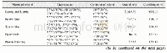
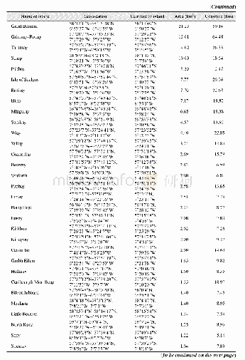
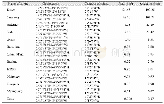
《Table 2 Continental coastline classification system of the East China》
 提示:宽带有限、当前游客访问压缩模式
本系列图表出处文件名:随高清版一同展现
《中国东海区大陆海岸线数据集(1990–2015)》
According to coastline type features in the East China Sea and natural state and artificial use mode of the coastline types and by referring to national basic coastline functional planning types,coastlines in 6 periods during 1990–2015 were divided into natural coastline and artificial coastline,both of which were then subdivided into several second-level types(Table 2).Per an international angle,average high-water line is generally used to indicate coastlines,so according to research needs and actual situation of the study area and based on an analysis of different reflective spectral features of surface features nearby the coastline,single-band(the5th waveband)edge detection of the processed remote sensing images in different periods was carried out so that a sea-land boundary line was obvious.Man-machine interactive interpretation was implemented on this basis,and the position of the coastline and its types were corrected by referring to an average high-water line method[4].
| 图表编号 | XD00110327600 严禁用于非法目的 |
|---|---|
| 绘制时间 | 2019.09.25 |
| 作者 | 李加林、田鹏、邵姝遥、赵梦琪 |
| 绘制单位 | 宁波大学东海研究院、宁波大学地理与空间信息技术系、宁波大学东海研究院、宁波大学地理与空间信息技术系、宁波大学东海研究院、宁波大学地理与空间信息技术系、宁波大学东海研究院、宁波大学地理与空间信息技术系 |
| 更多格式 | 高清、无水印(增值服务) |


