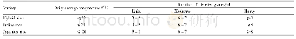
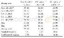
《Table 1 Classification standard of cold dew wind disaster for late rice production in Guangxi》
 提示:宽带有限、当前游客访问压缩模式
本系列图表出处文件名:随高清版一同展现
《Evaluation of Cold Dew Wind Monitoring Precision for Late Rice Based on CLDAS Data in Guangxi》
Due to the southward movement of strong cold air from the north,the temperature in Guangxi tends to decrease before and after the Cold Dew in September and October every year.If the temperature falls to a certain critical value,it can affect the normal heading,flowering and grouting of late rice,which can increase the empty shells and unfilled grins,finally resulting in yield reduction.Such phenomenon is commonly known as the cold dew wind weather,which is also a kind of disastrous weather.The cold dew wind weather for late rice is mainly monitored using daily average temperature as the indicator,which is also used as the standard to classify the disaster grades of cold dew wind weather(Table 1).
| 图表编号 | XD0028006500 严禁用于非法目的 |
|---|---|
| 绘制时间 | 2019.02.01 |
| 作者 | Yanli CHEN、Yan HE、Jianfei MO、Yongming LUO、Meihua DING |
| 绘制单位 | Guangxi Institute of Meteorological Disaster Mitigation、Remote Sensing Application Test Base,NSMC、Guangxi Collaborative Innovation Center for Ecological Environment & Integrative Development in Xijiang River Basin、Guangxi Institute of Meteorological Disas |
| 更多格式 | 高清、无水印(增值服务) |
