《Table 1Beach-facing slope, sediment characteristics, and closure depth (Courtaud 2000;E.O.L.2010)》下
 提示:宽带有限、当前游客访问压缩模式
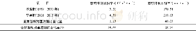
where dl,tis the predicted Dcover t years,referenced to LAT;He,tis the nearshore non-breaking wave height exceeding 12 h per t years,(100/(730×t)%of the time) ;Te,tis the associated wave period;and g is the acceleration due to gravity.In this paper,nearshore wave parameters at a water depth of 6–7 m were extracted from coupled wave and hydrodynamic numerical simulations over a period of 35 years from 1981 to 2015.The values of Dcgenerally ranged from 3 to 4 m(Table 1)but could reach 6–7 m during a limited storm event.In addition to the bathymetric data measured by E.O.L.,the relation between Dcand the beach profile configuration in the study areas was analyzed.Specifically,in Zone 1,Dcappeared about 250 m from the shoreline of the Gapeau and Aygaude beaches.In Zone 2,Dcappeared about 300 m seaward of the shoreline at La Marquise beach,about 340 m seaward of the shoreline from Plein Sud beach,about 280 m seaward of the shoreline from Aéroport beach,and about 170 m seaward of the shoreline from Amont beach.In Zone 3,Dcoccurred 148 m from the shoreline of Bona beach,180 m from the shoreline of Hyères beach,and 200 m from the shoreline of Pesquiers beach;it also occurred about 280 and 380 m,respectively,seaward of the shoreline of the La Capte and La Badine beaches.
| 图表编号 | XD0024728300 严禁用于非法目的 |
|---|---|
| 绘制时间 | 2018.06.25 |
| 作者 | Minh Tuan Vu、Yves Lacroix、Viet Thanh Nguyen |
| 绘制单位 | SEATECH, University of Toulon、University of Transport and Communications,Hanoi、SEATECH, University of Toulon、MEMOCS, Università Degli Studi dell'Aquila、University of Transport and Communications,Hanoi |
| 更多格式 | 高清、无水印(增值服务) |

