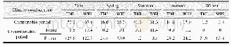
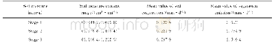
《Table 2 Average annual comfortable period and uncomfortable period on climate in China (1981–2010)(
 提示:宽带有限、当前游客访问压缩模式
本系列图表出处文件名:随高清版一同展现
《中国大陆不同空间尺度下的气候舒适与不舒适期数据集(1981–2010)——改进算法的模拟结果》
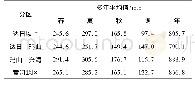
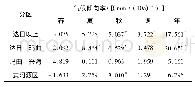
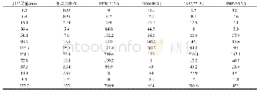
The comparison of THI value with WEI shows their better consistency.Based on the analysis of Figure 1,as far as comfortable periods are concerned,the southern is long and the northern is short.Among them,Yunnan province ranked the first,which provides a solid foundation for“Kunming every day is spring”,which means it is a good place to escape the hot summer and the frozen winter.The adjacent province Tibet autonomous region has theshortest period of comfortable.Hainan,Guangdong and Guangxi province became high value centers for torrid period.High altitude areas such as Qinghai province and Tibet autonomous region become extreme centers of frozen discomfort.Also,we evaluated the historical changes during the annual average climate comfortable period and uncomfortable period in China.In general,the uncomfortable period is much longer than the comfortable period,and the frozen period is much longer than the torrid period.As in other parts of the world,China has experienced noticeable changes in climate over the past years.The trend of climate warming in China is projected to intensify in the future.Methods provided similar results and formed an interactive verification indicating that the CCP in most regions showed an increasing trend from 1981 to 2010.
| 图表编号 | XD00206977300 严禁用于非法目的 |
|---|---|
| 绘制时间 | 2020.06.25 |
| 作者 | 蔚丹丹、李山 |
| 绘制单位 | 华东师范大学地理科学学院、地理信息科学教育部重点实验室、华东师范大学地理科学学院、地理信息科学教育部重点实验室、崇明生态研究院 |
| 更多格式 | 高清、无水印(增值服务) |
