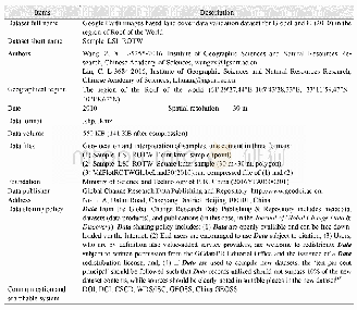
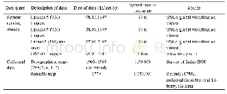
《Table 4 Description of data used for image classification and accuracy assessment》
 提示:宽带有限、当前游客访问压缩模式
本系列图表出处文件名:随高清版一同展现
《Evaluating and modeling the spatiotemporal pattern of regional-scale salinized land expansion in highly sensitive shoreline landscape of southeastern Iran》
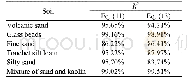
Note:KC,Kappa coefficient;OA,overall accuracy;FCC,false color composite.
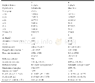
The results of image classification and accuracy assessment are given in Figure 3 and Table 4.Accordingly,all maps obtained overall accuracy(OA)and Kappa coefficient(KC)of more than0.94 and 0.90,respectively,indicating the acceptable accuracy of the image classification procedure.Based on the results,salinized land areas expended more than 1.19×10⁵ hm2 between1986 and 2015.In 1986,salinized land areas occupied approximately 1.79×10⁵ hm2 of the region(7.7%of the total area).With an annual growth rate of 0.28%,salinized land areas reached2.30×105 hm2 in 2000(9.8%of the total area).The study area was dramatically salt-affected between 2000 and 2015 where salinized land areas expanded with an annual growth rate of more than 0.29%and reached to 2.98×10⁵ hm2 in 2015(12.7%of the total area).
| 图表编号 | XD0020366000 严禁用于非法目的 |
|---|---|
| 绘制时间 | 2018.12.01 |
| 作者 | Mohammad SHAFIEZADEH、Hossein MORADI、Sima FAKHERAN |
| 绘制单位 | Department of Natural Resources, Isfahan University of Technology、Department of Natural Resources, Isfahan University of Technology、Department of Natural Resources, Isfahan University of Technology |
| 更多格式 | 高清、无水印(增值服务) |
