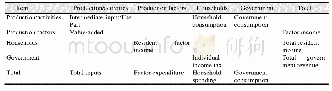
《Table 3 Components of the SAM table》
 提示:宽带有限、当前游客访问压缩模式
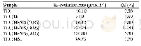
It can be found that the 42 industrial sectors analyzed by input-output analysis in China basically correspond to five types of state-owned construction land,such as transportation land,industrial and mining land,and storage land,in the classification of land use status in China[5](Table 2).According to the division of construction land and the definition of the industry in the land classification,five industries,including information transmission,software,and information technology services in the input-output table can correspond to commercial service land.27 industries were compared with industrial and mining storage land.Seven industries,including scientific research and technical services,water conservancy,environment,and public facilities management,will be matched with public management and public service land.The real estate industry could be matched with residential land.42sections in the table have some overlapping fields,so it cannot fully correspond to the classification of land use status,such as the classification of warehousing.Since the warehousing industry and the transportation industry are merged into the transport,storage and post industry(code 30)in the input-output table of China,they cannot be separated.Here,warehousing industry refers to goods transportation,transit warehousing,and goods distribution mainly engaged in warehousing.Its main business belongs to the same category as transportation,so the transportation and storage industry were matched with transportation land.The special land in the state-owned construction land includes the land for military facilities,embassies,and consulates;the water area and water conservancy facilities in the construction land include the water surface of reservoirs,coastal beaches,and other land including idle land.Taking Beijing as an example,in 2012,the special land,water and water conservancy facilities land,and other land in Beijing were 3.33,6.83,and 0 hm2,respectively[6],which accounted for a small proportion and were not closely related to the city’s social economy,so they were not included in the research scope.Since this dataset is mainly used to study the structure of urban construction land,the data for agriculture,forestry,animal husbandry,fishery,and corresponding agricultural land data in the input-output table are excluded.Other departments[1]and match the standard CGE model,including elements,residents,government,and summary departments.
| 图表编号 | XD00153328900 严禁用于非法目的 |
|---|---|
| 绘制时间 | 2020.03.25 |
| 作者 | 张扬、马天乐 |
| 绘制单位 | 湖南财政经济学院、长沙环境保护职业技术学院 |
| 更多格式 | 高清、无水印(增值服务) |
![表3 冻土组成物质的导热系数 (W·m-1·K-1) [31]Table 3The thermal conductivities of various frozen soil components (W·m-1·K-1) [31]](http://bookimg.mtoou.info/tubiao/gif/BCDT201801015_40500.gif)
