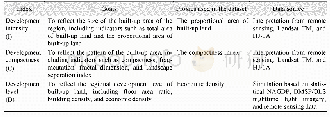
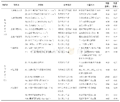
《Table 2 Evaluation index system used to determine regional three-dimensional(3-D)development densit
 提示:宽带有限、当前游客访问压缩模式
Because the traditional concept of regional development density overlooks the spatial distribution pattern and the development level of built-up land,in this dataset a three-dimensional(3-D)evaluation model of regional development density was constructed.The three dimensions were the scale of built-up land,spatial distribution pattern,and development density.The scale of built-up land was indicated by the index of development intensity(I).The spatial distribution pattern was determined by the index of development compactness(C),which has several indicators,such as the compactness index,the fragmentation index,and the fractal dimension.The development density(D)can be reflected by several indicators such as building height,building density,floor area ratio,and economic density(Table 2).Considering the data availability and computational convenience,the proportional area of built-up land was used as a proxy of the development intensity,the development compactness was indicated by the compactness index from the landscape index,and the development level was indicated by the economic density of the built-up land.For the calculation of economic density,the available statistics were all based on administrative units,and were mainly at or above the county level.Therefore,they could not indicate the spatial differences of economic density inside the county,which limits the evaluation of regional development density.Therefore,the dataset used DMSP/OLS nighttime lighting data,built-up land data,and statistical data to map the finer scale non-agricultural GDP(NAGDP).
| 图表编号 | XD00110307600 严禁用于非法目的 |
|---|---|
| 绘制时间 | 2019.03.25 |
| 作者 | 李升发、叶玉瑶 |
| 绘制单位 | 广州地理研究所广东省地理空间信息技术与应用公共实验室、广州地理研究所广东省地理空间信息技术与应用公共实验室 |
| 更多格式 | 高清、无水印(增值服务) |
