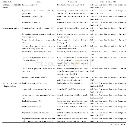
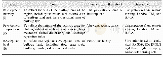
《Table 1 Index system for land use regionalization in Luquan County》
 提示:宽带有限、当前游客访问压缩模式
本系列图表出处文件名:随高清版一同展现
《Land Use Regionalization in Poor Counties in Mountainous Areas Based on Targeted Poverty Alleviation》
The key step in land use regionalization is the selection of indices.Different indices selected directly results in different regionalization results.Therefore,according to the purpose of land use regionalization in this paper,representative indices were selected carefully.Combining the social and economic development status and land use status of Luquan County,with reference to its progress in poverty alleviation,requirements of various development plans,and acquisition of data,4 primary indices were selected,ecological environment,socioeconomics,land resources and land use,and direction of poverty alleviation and development and key ways to alleviate poverty,and 23 secondary indices were selected(Table 1).
| 图表编号 | XD00114988700 严禁用于非法目的 |
|---|---|
| 绘制时间 | 2020.01.01 |
| 作者 | Qiude LI、Zisheng YANG |
| 绘制单位 | Institute of Land & Resources and Sustainable Development,Yunnan University of Finance and Economics、Institute of Land & Resources and Sustainable Development,Yunnan University of Finance and Economics |
| 更多格式 | 高清、无水印(增值服务) |