《Table 1 The major system influencing the moving out of Qinghai-Tibet Plateau shear lines from 2000
 提示:宽带有限、当前游客访问压缩模式
本系列图表出处文件名:随高清版一同展现
《2000-2015年青藏高原切变线统计特征分析(英文)》
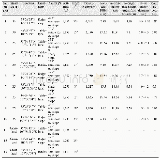
The duration of the various types of shear lines is different.As shown in Fig.4,when the life history was12 h,the number of shear lines was the largest,a total of375 times,accounting for 63.45%,while when the life history was 24 hours,a total of 149 times,accounting for25.21%.With the gradual extension of the life history,the number of plateau shear line shows a decreasing trend,in which the longest duration of the plateau shear line was72 h,only appeared one time,and the shear line was finally removed from the eastern part of the plateau.For the plateau east shear line which was not removed,its life history was similar to that of the plateau shear line.For the plateau east shear line which was removed,its life history was concentrated in the range of 24~36 h,a total of 68removals in the eastern part of the plateau,accounting for78.16%;plateau west only has one shear line removal,the duration was 60 h.It can be seen that the life history of the plateau shear line which was removed was generally longer than that of the plateau shear line which was not removed.
| 图表编号 | XD006796700 严禁用于非法目的 |
|---|---|
| 绘制时间 | 2018.02.01 |
| 作者 | 李潇濛、赵琳娜、肖天贵、杨瑞雯 |
| 绘制单位 | 成都信息工程大学大气科学学院高原大气与环境四川省重点实验室、中国气象科学研究院灾害天气国家重点实验室、成都信息工程大学大气科学学院高原大气与环境四川省重点实验室、中国气象科学研究院灾害天气国家重点实验室、成都信息工程大学大气科学学院高原大气与环境四川省重点实验室、成都信息工程大学大气科学学院高原大气与环境四川省重点实验室、中国气象科学研究院灾害天气国家重点实验室 |
| 更多格式 | 高清、无水印(增值服务) |
