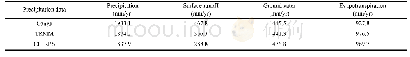
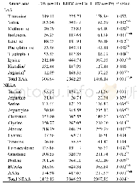
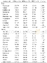
《Table 6 Comparison of the water balance components among hydrological simulations driven by gauge,
 提示:宽带有限、当前游客访问压缩模式
本系列图表出处文件名:随高清版一同展现
《Hydrological Simulation Using TRMM and CHIRPS Precipitation Estimates in the Lower Lancang-Mekong River Basin》
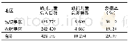
Flow data were collected from five hydrological stations on the main stream,including Chiang Saen,Luang Prabang,Nong Khai,Pakse and Stung Treng station(Fig.1).The catchment area and mean annual flow are given in Table 1.At Chiang Saen station,the inlet of the study area,the catchment area is 189×103 km2,with an annual flow of about 85.1×10⁹ m3.At Stung Treng station,the outlet of the study area,the catchment area is635×103 km2,and the annual runoff volume is about413.1×109 m3.The runoff of the study area accounts for about 69%of that in the whole Lancang-Mekong River Basin.
| 图表编号 | XD0046955600 严禁用于非法目的 |
|---|---|
| 绘制时间 | 2019.02.01 |
| 作者 | LUO Xian、WU Wenqi、HE Daming、LI Yungang、JI Xuan |
| 绘制单位 | Asian International Rivers Center, Yunnan University、Yunnan Key Laboratory of International Rivers and Transboundary Eco-security、Asian International Rivers Center, Yunnan University、Asian International Rivers Center, Yunnan University、Yunnan Key Laborato |
| 更多格式 | 高清、无水印(增值服务) |
