《Table 1–pH value of soil samples.》
 提示:宽带有限、当前游客访问压缩模式
本系列图表出处文件名:随高清版一同展现
《"Development of a model to simulate soil heavy metals lateral migration quantity based on SWAT in Huanjiang watershed,China"》
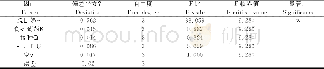
Representation of sampling location.After collection of spatial data,such as land-use type and DEM,for runoff volume and sediment amount simulation,data used for model development were collected from four runoff plots with areas of4 m×10 m(Fig.3).The representative of these four runoff plots lies in:(1)the soil type in the first,second and fourth runoff plots was red soil,and the average percentages of clay,silt and sand of red soil were 45.91%,45.09%and 9%,respectively.The soil type in the third runoff plot was calcareous soil,and the average percentages of clay,silt and sand of calcareous soil were 31.06%,44.94%and 24%,respectively.These four plots could represent the soil type of whole watershed well;(2)the average soil p H values of three points in the first and fourth runoff plots was 5.34 and 7.76,respectively,while the average pH values in the second and third runoff plots were both about6.84.The pH values of these four plots could cover the most pH values of the whole watershed(Table 1).
| 图表编号 | XD0033517400 严禁用于非法目的 |
|---|---|
| 绘制时间 | 2019.03.15 |
| 作者 | Pengwei Qiao、Mei Lei、Sucai Yang、Jun Yang、Xiaoyong Zhou、Nan Dong、Guanghui Guo |
| 绘制单位 | Institute of Geographic Sciences and Natural Resources Research, Chinese Academy of Sciences、Beijing Key Laboratory of Remediation of Industrial Pollution Sites, Environmental Protection Research Institute of Light Industry、Institute of Geographic Science |
| 更多格式 | 高清、无水印(增值服务) |
