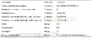
《Table 6 Layer Attribute of Geo-hazard Dataset》
 提示:宽带有限、当前游客访问压缩模式
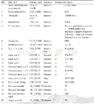
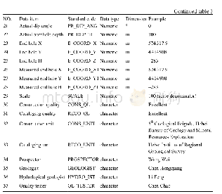
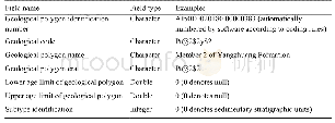
In ArcGIS,each layer should have the corresponding file and attribute list.Generally,the files have been divided as point file,line file and plane file.The attribute lists have been divided into the geo-hazard attribute list and geological attribute list(see Table 6).The geo-hazard attribute list has been divided as Landslide Hazard Attribute List and Collapse Hazard Attribute List.Meanwhile,the geological attribute list is mainly the plane attribute list of comprehensive geological body.
| 图表编号 | XD00191987100 严禁用于非法目的 |
|---|---|
| 绘制时间 | 2018.09.01 |
| 作者 | 李刚、杨秀元、李浩、乐琪浪 |
| 绘制单位 | 中国地质调查局水文地质环境地质调查中心、中国地质调查局水文地质环境地质调查中心、中国地质调查局水文地质环境地质调查中心、中国地质调查局水文地质环境地质调查中心 |
| 更多格式 | 高清、无水印(增值服务) |

