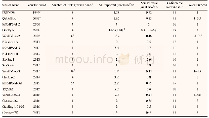
《Table 1 High resolution satellite sensors with spatial resolutions of 5 m or finer in multispectral
 提示:宽带有限、当前游客访问压缩模式
本系列图表出处文件名:随高清版一同展现
《High resolution satellite imaging sensors for precision agriculture》
Note:aAll sensors except the ones with a superscript have four standard spectral bands(blue,green,red and near-infrared);bat nadir;cretired in 2015;dorbit altitude was raised in 2013;eeight spectral bands (coastal,blue,green,yellow,red,red edge,n
The above satellite imaging sensors constitute most of the current arena of high resolution satellite remote sensing.More and more satellite imaging sensors will be launched in the coming years.This is a very dynamic area that changes all the time.Imagery from most of the satellite sensors listed in Tables 1–2 can be ordered from various online sources.A tasking order can be made by defining a custom polygon on Earth to be imaged by the next available high resolution satellite.The area of interest(AOI)can be specified by WGS-84 latitude/longitude or UTM grid coordinates with zone number.The customer can upload the AOI in one of several file formats(txt,pdf,kmz/kml or ESRI shapefile).Some websites allow the drawing of the AOI online.The time to collect the AOI is controlled by local weather conditions and competition from surrounding tasking orders.An archive order can also be made from a historic database of high resolution satellite images with specific dates.
| 图表编号 | XD0017389600 严禁用于非法目的 |
|---|---|
| 绘制时间 | 2018.12.01 |
| 作者 | Chenghai YANG |
| 绘制单位 | United States Department of Agriculture,Agricultural Research Service,Aerial Application Technology Research Unit,College Station |
| 更多格式 | 高清、无水印(增值服务) |

![Table 4 Urban cell ratio of Moore neighborhood in different resolution[14]](http://bookimg.mtoou.info/tubiao/gif/QQSJ201903009_05600.gif)
![Table 2 Verification results of 1-D detonation wave under different grid resolution[32]](http://bookimg.mtoou.info/tubiao/gif/TJJS201902021_08700.gif)