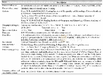
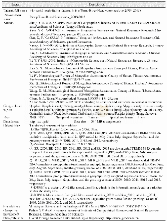
《Table 1 Metadata summary of“School districts dataset of middle and primary public school in Nanjing
 提示:宽带有限、当前游客访问压缩模式
本系列图表出处文件名:随高清版一同展现
《"南京主城区公办(初)中小学学区分布对比数据集(2008,2018)"》
According to the education map and the list of schools on the website of the Education Bureau of Nanjing City and other administrative districts,data on the spatial distribution of the primary school and middle school educational resources,their school area,school district,and other basic education facilities in the main urban area of Nanjing in 2018 were obtained.The corresponding data in 2008 come from the data contained in the“Campus land planning of primary school and middle school in Nanjing(2006–2020)”,“The statistical yearbook of Nanjing”and the 2008 edition of the map of Nanjing[23–25].Data on Nanjing Foreign Language School’s admission rate and the average score of middle school entrants were compiled from the Municipal Education Bureau as well as the soxue.com,and the data of campus area were compiled from soxue.com[26–28].For some schools that could not be found,their respective area was digitized by using Google map satellite imagery and calculated in Arc GIS software.The spatial database of educational facilities in Nanjing’s primary schoolsand middle schools were established using the Baidu Map tool,by collecting the longitude and latitude information of the schools’geographical position,and then arranging,compiling,and analyzing this collected data.As a result of the 2013 administrative territorial entity adjustment in Nanjing,this dataset has been revised for primary schools and middle schools in 2008 based on the latest(2018)administrative territorial entity’s location.
| 图表编号 | XD00153334600 严禁用于非法目的 |
|---|---|
| 绘制时间 | 2020.03.25 |
| 作者 | 陈艳如、涂唐奇、宋伟轩 |
| 绘制单位 | 中国科学院南京地理与湖泊研究所、中国科学院大学、中国科学院大学、中国科学院科技战略咨询研究院、中国科学院南京地理与湖泊研究所、中国科学院南京地理与湖泊研究所流域地理学重点实验室 |
| 更多格式 | 高清、无水印(增值服务) |