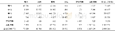
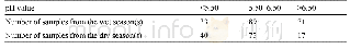
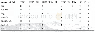
《Table 9 Summary Table of the groundwater hydrochemical types in the survey area》
 提示:宽带有限、当前游客访问压缩模式
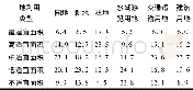
The environmental geological survey on a scale of 1∶50 000 in the Longmen Map Sheet covers 405 various survey points,primarily including 221 pumping(domestic)well survey points and 77 comprehensive geological survey points in the field,accounting for 55%and19%of the total survey point number respectively.In addition,there are 77 geological boundary points,7 surface water survey points,21 spring points and 3 geological structural survey points.Therefore,there are about 84 survey points per 100 km2 on average,since the Longmen Map Sheet covers an area of about 480 km2,reaching the survey point density in complex mountainous and hilly areas.The interval between routines is 1000-1200 m,compliant with the relevant requirements for medium complex areas.Pumping tests were carried out in 10 hydrogeological survey boreholes.Furthermore,there are 56 points where the water level will be simultaneously measured and 56 points from which water samples were taken for water-quality analysis;thereby meeting the quota requirement for water-quality analysis point number per 100 km2 in complex mountainous and hilly areas specified in Specification for Hydrogeological Survey(1∶50 000)(DZ/T 0282-2015).
| 图表编号 | XD00149443000 严禁用于非法目的 |
|---|---|
| 绘制时间 | 2019.12.01 |
| 作者 | 余绍文、黎清华、刘凤梅、张彦鹏 |
| 绘制单位 | 中国地质调查局武汉地质调查中心、中国地质调查局武汉地质调查中心、中国地质调查局武汉地质调查中心、中国地质调查局武汉地质调查中心 |
| 更多格式 | 高清、无水印(增值服务) |