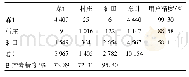
《Table 2 Sample types in GlobeLand30》
 提示:宽带有限、当前游客访问压缩模式
本系列图表出处文件名:随高清版一同展现
《基于Google Earth的世界屋脊生态地理区GlobeLand30(2010)验证点数据集》
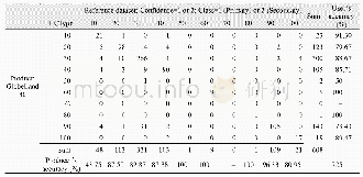
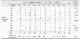
The sampling adopts a Landscape-Shape-Index-based method[21]recommended by the project,and the specific operation is completed on the project platform[22].Considering the complexity of this region,95%confidence level was selected for sampling.At this level,801validation points are extracted(Figure 1,Table 2).Figure 1 shows that the sampling density is relatively small in the vast area above the plateau,while in the southern fringe area,the ground heterogeneity is strong and the sampling density is high.
| 图表编号 | XD00110329100 严禁用于非法目的 |
|---|---|
| 绘制时间 | 2019.09.25 |
| 作者 | 王正兴、刘闯、Win Naing Tun |
| 绘制单位 | 中国科学院地理科学与资源研究所资源环境信息系统国家重点实验室、中国科学院地理科学与资源研究所资源环境信息系统国家重点实验室、Resource and Environment Myanmar Co., Ltd. |
| 更多格式 | 高清、无水印(增值服务) |


