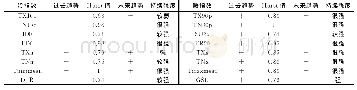
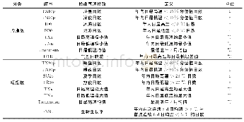
《Table 1 Definitions of extreme temperature indices》
 提示:宽带有限、当前游客访问压缩模式
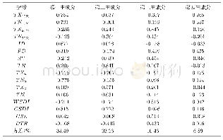
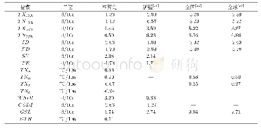
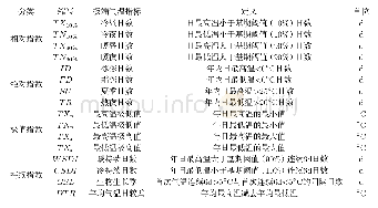
Within the context of global warming,extreme temperature events such as heatwaves and cryogenic freezing have occurred frequently in the coastal area of China,which have caused serious impacts on regional ecological environment protection,socio-economic sustainable development as well as people’s properties and lives[1-4].Based on daily maximum and minimum temperature dataset of 156 meteorological station records from 1961 to 2014 in the coastal area of China,time series of 16 extreme temperature indices(Table 1)were performed by the software RClimDex[5],and then the multi-year average and inter-annual magnitude[6]in all extreme temperature indices were worked out on the meteorological site scale during the considering period.Furthermore,raster dataset of multi-year average and inter-annual magnitude in extreme temperature indices in the coastal area of China from 1961to 2014[7]were produced using Inverse Distance Weight interpolation method in ArcGIS software.Raster dataset of extreme temperature is expected to raise awareness of the temporal and spatial patterns of extreme temperature events in the coastal area of China.
| 图表编号 | XD00110305100 严禁用于非法目的 |
|---|---|
| 绘制时间 | 2019.03.25 |
| 作者 | 王晓利、侯西勇 |
| 绘制单位 | 中国科学院烟台海岸带研究所、中国科学院海岸带环境过程与生态修复重点实验室、中国科学院烟台海岸带研究所、中国科学院海岸带环境过程与生态修复重点实验室 |
| 更多格式 | 高清、无水印(增值服务) |
