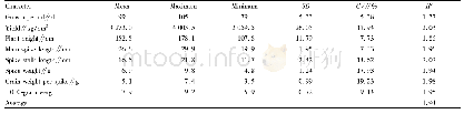
《Table 2 Main RDLS parameters of western Henan mountainous area》
 提示:宽带有限、当前游客访问压缩模式
本系列图表出处文件名:随高清版一同展现
《基于栅格的豫西山区地形起伏特征及其对人口和经济的影响(英文)》
The distribution ratios and the cumulative frequencies of RDLS in the study area are shown in Figure 3b.It can be seen that the topographical relief degree is low generally.From Table 2,it can be seen that areas with a relief degree of 0–0.1 account for the largest proportion(24.21%),the average relative elevation is only 48.98 m and the area of flat land is the largest(70.41%).Areas with a relief degree above 1.6 account for only 0.49%of the study area,the average relative elevation is 864.74 m and the area of flat land is minimal(0.20%).Thus,as the relief degree increases,the relative elevation gradually increases and the proportion of flat land gradually decreases.From Figure 3b and Table 2,when the relief degree reaches 0.5,the average relative elevation does not exceed 250 m and the cumulative frequency reaches 58.6%.When the relief degree reaches 1,the average relative elevation is≤500 m and the cumulative frequency reaches 89.76%.When the relief degree reaches 1.6,the average relative elevation is≤800 m and the cumulative frequency reaches as high as99.51%.
| 图表编号 | XD0062094600 严禁用于非法目的 |
|---|---|
| 绘制时间 | 2019.04.01 |
| 作者 | 张静静、朱文博、朱连奇、崔耀平、何莎莎、任涵 |
| 绘制单位 | College of Environment and Planning,Henan University、College of Environment and Planning,Henan University、College of Environment and Planning,Henan University、College of Environment and Planning,Henan University、College of Environment and Planning,Henan U |
| 更多格式 | 高清、无水印(增值服务) |

