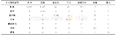
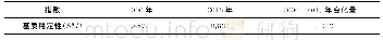
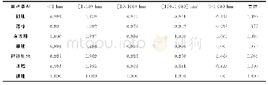
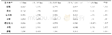
《表2 乌江中上游景观转移矩阵Tab.2 Transition matrix of landscape types in middle and upper reaches of the Wujiang
提示:宽带有限、当前游客访问压缩模式
本系列图表出处文件名:随高清版一同展现
《2000年和2015年乌江中上游景观稳定性变化研究》
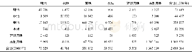
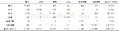
km2
15年间耕地转为森林最为突出,高达1 305km2。耕地转为草地和建设用地相对较大,分别为321km2和270km2。其他景观之间转化相对较小。裸地与其他景观之间均无转化(表2)。
图表编号 | XD0032543000 严禁用于非法目的 |
---|---|
绘制时间 | 2019.01.25 |
作者 | 韩会庆、蔡广鹏、尹昌应、马庚、张英佳、陆艺 |
绘制单位 | 贵州理工学院建筑与城市规划学院、贵州师范大学地理与环境科学学院、贵州理工学院建筑与城市规划学院、贵州理工学院建筑与城市规划学院、贵州理工学院建筑与城市规划学院、贵州理工学院建筑与城市规划学院 |
更多格式 | 高清、无水印(增值服务) |
查看“表2 乌江中上游景观转移矩阵Tab.2 Transition matrix of landscape types in middle and upper reaches of the Wujiang”的人还看了
- 表2 1 9 9 0-2000年土地利用类型转移矩阵 (单位:km2) Table 2 Transition matrix of the land use types from 1990 through 2000 (unit:km2)
- 表3 2000-2010年土地利用类型转移矩阵 (单位:km2) Table 3 Transition matrix of the land use types from 2000 through 2010 (unit:km2)
- 表3 1990—2015年太行山区土地利用转移矩阵表Tab.3 The table of land-use transition matrix in Taihang mountainous areas from 1990 to 2015 (
- 表3 乌江中上游景观基质稳定性指数Tab.3 Stability index of the landscape matrix in middle and upper reaches of the Wujiang