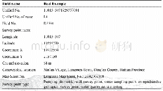
《Table 2 Composition of the lower timberline dataset in the Upper Reaches of the Min River(1999-2009
 提示:宽带有限、当前游客访问压缩模式
本系列图表出处文件名:随高清版一同展现
《岷江上游林树下线地理分布及实地调查样本点数据集(1999-2009)》
The data indicated that:(1)the discontinuous lower timberline in URMR was located near the upper boundary of the arid valley.The altitude of the lower timberline ranged from 1,400m to 3,800 m,with a normal distribution at the center of 2,600 m(Figure 4).The distribution slope of the lower timberline was mainly below 25 degrees and the per cent of lower timberline reached the peak on the slopes of 6°-15°.Moreover,the lower timberline on the southern slope was obviously higher than that on the northern slope,and that in the eastern part was higher than that in the western.(2)the length of lower timberline increased from 2009to 1999[5].
| 图表编号 | XD0027627200 严禁用于非法目的 |
|---|---|
| 绘制时间 | 2017.12.25 |
| 作者 | 王青、郭亚琳、翟真 |
| 绘制单位 | 西南科技大学环境与资源学院、西南科技大学环境与资源学院、西南科技大学环境与资源学院 |
| 更多格式 | 高清、无水印(增值服务) |
查看“Table 2 Composition of the lower timberline dataset in the Upper Reaches of the Min River(1999-2009)”的人还看了
-

- Table 2 The changes in the paid-up capital composition of the food industry in the three northeastern provinces of China
-

- Table 2 Composition of the“Autumn phenological grid dataset of typical deciduous broad-leaved woody plants in the warm t


