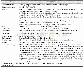
《Table 2 The statistics of the Elevation Cluster Dataset》
 提示:宽带有限、当前游客访问压缩模式
According to the topography characteristics of Yenisei River Basin,a total of 10 elevation clusters were developed(Table 2).In order to reflect the distribution characteristics of low-altitude areas,elevation less than500 m was divided into four intervals.The elevation more than 3,000 m was divided as a single interval.The rest elevation from 500 m to 3,000 m was divided by an interval of 500 m.The Elevation Cluster Dataset Covering the Yenisei River Basin shows that the lowland area lower than 500 m is1.65×105 km2,accounting 6.21%of the basin area;the area with elevation from50 to 100 m is 9.93×10⁴ km2 accounting 3.74%of the basin area;the land with elevation between 100 m and 200m is 1.71×10⁵ km2,about 6.43%of the total area of the basin.In Yenisei River Basin,the main part with area 9.75×10⁵km2 locates between 200 m and 500 m,which accounts about 36.66%of the basin;the land with elevation between500 m and 1,000 m is 5.70×10⁵ km2,12.27%of total area of the basin.The mountain land more than 1,500 m above sea level accounts 13.26%of the basin area.The dataset was archived as.tif file with 112 MB compressed data size.The Elevation Cluster Dataset Covering the Yenisei River Basin is shown in Figure 4,and the statistics value is shown in Table 2.
| 图表编号 | XD0027617500 严禁用于非法目的 |
|---|---|
| 绘制时间 | 2017.06.29 |
| 作者 | 杨阿强、刘闯、石瑞香 |
| 绘制单位 | 中国科学院遥感与数字地球研究所、中国科学院地理科学与资源研究所、中国科学院地理科学与资源研究所 |
| 更多格式 | 高清、无水印(增值服务) |

![Table 2 Sampling validation of the dataset[14]](http://bookimg.mtoou.info/tubiao/gif/QQSJ201903009_05200.gif)
