《Tab.1 Index system of flood risk assessment of Cinanfeizuopian flood control protected zone》
 提示:宽带有限、当前游客访问压缩模式
本系列图表出处文件名:随高清版一同展现
《组合赋权-模糊聚类算法的改进及其在洪灾风险评价的应用》
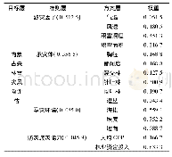
The grid units have obvious distribution characteristics of carrier information and accurate spatial positions.With the support of the GIS spatial analysis technology,the 150m×150mgrid is used as the basic unit for the assessment of the Cinanfeizuopian flood control protected zone,and the flood control protected zone is divided into 64 592grids according to the area of the flood control protected zone,the distribution of indexes,disaster characteristics,sizes of townships,and the topographic feature.The indexes are normalized according to the method stated in Section 1.1.The distribution of some assessment indexes of the Cinanfeizuopian flood control protected zone is shown in Fig.3.Correlation analysis is conducted for the indexes.The results show that the correlation coefficients between the assessment indexes are all smaller than 0.9,and the interactions between the indexes are within a reasonable range.
| 图表编号 | XD00224305200 严禁用于非法目的 |
|---|---|
| 绘制时间 | 2020.10.25 |
| 作者 | 潘汀超、戚蓝、田福昌、苑希民 |
| 绘制单位 | 天津大学水利工程仿真与安全国家重点实验室、天津大学水利工程仿真与安全国家重点实验室、天津大学水利工程仿真与安全国家重点实验室、天津大学水利工程仿真与安全国家重点实验室 |
| 更多格式 | 高清、无水印(增值服务) |


