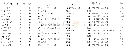
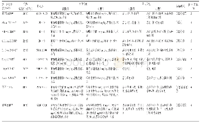
《Table 1 Information of TCN 10Be exposure ages studies of Tibetan Plateau》
 提示:宽带有限、当前游客访问压缩模式
本系列图表出处文件名:随高清版一同展现
《~(10)Be Exposure Ages Obtained From Quaternary Glacial Landforms on the Tibetan Plateau and in the Surrounding Area》
The Tibetan Plateau is called“the roof of the world”and“the third pole”,which caused by the Indian-Eruasian continental collision since 50 million years ago,forms the youngest and highest altitude Plateau on Earth.A large number of geophysical and geological surveys have found that the major tectonic features of the Tibetan Plateau show a significant difference between north and south directions,and is divided into several terranes by faults and suture(Fig.1).(Shi Yafeng et al.,1999a;Kind et al.,2002;Zheng Du and Yao Tandong,2004;Zhou et al.,2005;Li et al.,2016a;Tang et al.,2016;Zhang et al.,2016).The Tibetan Plateau stretches from the Himalayan Mountains in the south to the Kunlun,Altun and Qilian Mountains in the north and from the Pamirs and the Hindu Kush to the west to the western part of the Qinling Mountains and the Loess Plateau to the east and northeast.The average altitude of the Tibetan Plateau is over 4000m,and its glacier-covered area is approximately 47thousand km2,which accounts for more than 80%of the total area of glaciers in the country.The Tibetan Plateau contains the largest extent of modern glaciers outside of the polar regions(Owen and Dortch,2014;Yao Tandong et al.,2017;Chen Guohui and Ma Ling,2017).For this study,we collected 1848 10Be ages obtained from the Tibetan Plateau and the peripheral mountain ranges published from 1999 to 2017 in 56 articles.We extracted the information relevant to TCN exposure dating for the sampling locations(latitude,longitude,altitude,altitude flag,sample thickness and density,shielding correction and erosion)and the measured parameters(concentration of 10Be,uncertainty in 10Be concentration,and name of10Be standardization).The distributions of these data are shown in Figure 2.The data were collected within an area that extends from 27.04°N to 43.74°N and from 69.50°E to 102.74°E;the corresponding study areas(1–36)are shown in Table 1.Most(1798;approximately 97.3%)of the samples were collected from boulders;samples from cobbles(22;approximately 0.8%),bedrock(15;approximately 1.2%),roches moutonnées(7;approximately 0.4%)and sediments(6;approximately0.3%)make up a small part of the dataset.
| 图表编号 | XD0017173900 严禁用于非法目的 |
|---|---|
| 绘制时间 | 2018.04.01 |
| 作者 | ZHANG Mengyuan、MEI Jing、ZHANG Zhigang、WANG Jian、XU Xiaobin |
| 绘制单位 | School of Geographical Sciences, Nanjing Normal University、Key Laboratory of Virtual Geographic Environment (Nanjing Normal University), Ministry of Education、Jiangsu Center for Collaborative Innovation in Geographical Information Resource Development and |
| 更多格式 | 高清、无水印(增值服务) |