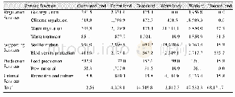
《Table 4 Value of ecosystem services per unit area in Yarkant River basin》
 提示:宽带有限、当前游客访问压缩模式
本系列图表出处文件名:随高清版一同展现
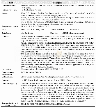
《1978–2018年叶尔羌河流域土地利用及其生态服务价值变化数据研究》
where n is the crop type.The Yarkant River basin includes Yarkant County,Poskam County,Kargilik County,Makit County,and Maralbexi County.The main crops in these areas are wheat,rice,corn,padanmu,red dates,walnuts,and beans.Pi refers to the current price of grain crops(Yuan·t-1),q refers to the per unit area yield of grain type i(t·hm-2),and m refers to the area of grain crop i(hm2).M denotes the total area of food crops(hm2).According to the statistical yearbook,the average economic value of V in the study area for 1978,1988,1998,2008,and 2018 is 1575.5(Yuan·hm-2·a-1).Finally,using Equation(4),the ESV coefficients of the six land types in the Yarkant River basin can be calculated.The results are presented in Table 4.
| 图表编号 | XD00153337100 严禁用于非法目的 |
|---|---|
| 绘制时间 | 2020.03.25 |
| 作者 | 王建平、阿依努尔·买买提、马元旭 |
| 绘制单位 | 中国科学院空天信息创新研究院喀什卫星地面站、中国科学院空天信息创新研究院喀什卫星地面站、中国科学院空天信息创新研究院数字地球重点实验室 |
| 更多格式 | 高清、无水印(增值服务) |


