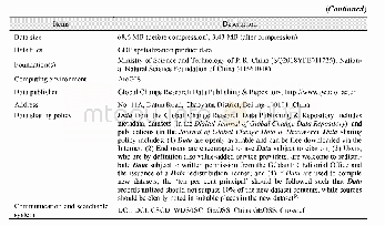
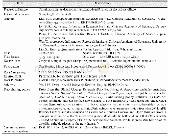
《Table 1 Metadata summary of the“Dataset of strategical transformation regionalization for the agric
 提示:宽带有限、当前游客访问压缩模式
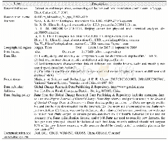
In the dataset,we selected the percentage of areas of cropland,basic farmland,and high-yielding fields in each town to represent the proportion of cropland or high-quality cropland.For water resources,the percentage of areas with a recharge modulus greater than200,000 m3/(a·km2)or lower than 10,000 m3/(a·km2)were used to represent the volume of water resources used for agricultural irrigation.For climate,we chose the percentage area with precipitation lower than 200 mm to represent the amount of precipitation.For terrain,we selected the percentage of areas above 15°or 25°slope to represent the limiting factor of the terrain.For geomorphology,the percentage of areas of mountains,hills,and plains were selected to analyze the suitability of ACD.For the distribution of ACD projects,the percentage of areas of high-standard farmland projects and the planning projects to 2020 represent the development levels of the past and future.For ecological planning,the percentage area devoted to agriculture-related functions was selected as being representative of agricultural importance.
| 图表编号 | XD00110317700 严禁用于非法目的 |
|---|---|
| 绘制时间 | 2019.06.25 |
| 作者 | 史文娇、王鸣雷 |
| 绘制单位 | 中国科学院地理科学与资源研究所中国科学院陆地表层格局与模拟院重点实验室、中国科学院大学资源与环境学院、中国科学院地理科学与资源研究所中国科学院陆地表层格局与模拟院重点实验室、中国科学院大学资源与环境学院 |
| 更多格式 | 高清、无水印(增值服务) |