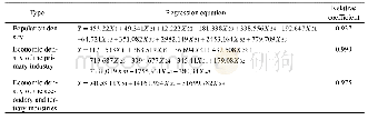
《Table 1 Relationship between population density, economic density and the corresponding land use ty
 提示:宽带有限、当前游客访问压缩模式
本系列图表出处文件名:随高清版一同展现
《基于栅格的豫西山区地形起伏特征及其对人口和经济的影响(英文)》
Firstly,the county and town boundaries were superimposed on the land use map to calculate the land use type index in every county and town.Next,a multiple regression model was established by taking the population density data of 338 towns,and the economic density data of different sectors in 29 counties as the dependent variables,and their corresponding land use type indices as the independent variables.Based on the Liao’s study the constant term was set to 0(Liao et al.,2015).The regression function is shown in Table 1,it can be seen that the correlation coefficients are high,indicating good fitting effects.
| 图表编号 | XD0062095000 严禁用于非法目的 |
|---|---|
| 绘制时间 | 2019.04.01 |
| 作者 | 张静静、朱文博、朱连奇、崔耀平、何莎莎、任涵 |
| 绘制单位 | College of Environment and Planning,Henan University、College of Environment and Planning,Henan University、College of Environment and Planning,Henan University、College of Environment and Planning,Henan University、College of Environment and Planning,Henan U |
| 更多格式 | 高清、无水印(增值服务) |
