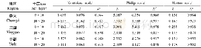
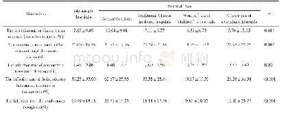
《Table 3 The WCQ of different forest types in the URWR[16]》
![《Table 3 The WCQ of different forest types in the URWR[16]》](http://bookimg.mtoou.info/tubiao/gif/QQSJ201804010_32800.gif) 提示:宽带有限、当前游客访问压缩模式
提示:宽带有限、当前游客访问压缩模式
Based on remote sensing data,Zhang et al.[17]found that forest WCC initially increased before it declined with an increase in elevation in Liuhe county,Jilin province;these results are in contrast with our findings that forest WCC declined with an increase of elevation.However,the elevation range in the study by Zhang et al.[17]was less than in our study(303-1,257 m),and its forest WCQ increased with elevations below 750 m,reaching a maximum at 750-850 m,before decreasing at higher elevations.We conclude that our findings are valid,because the elevation range in our study(between 700 and 2,900 m)coincided with that when forest WCQ began to fall in the study of Zhang et al.[17].
| 图表编号 | XD0027640000 严禁用于非法目的 |
|---|---|
| 绘制时间 | 2018.12.24 |
| 作者 | 唐玉芝、邵全琴 |
| 绘制单位 | 中国科学院地理科学与资源研究所陆地表层格局与模拟院重点实验室、中国科学院大学、中国科学院地理科学与资源研究所陆地表层格局与模拟院重点实验室、中国科学院大学 |
| 更多格式 | 高清、无水印(增值服务) |