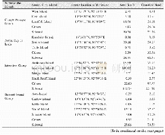
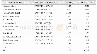
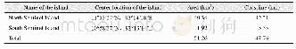
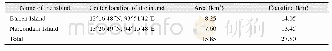
《Table 4 Geo-location,area and length of coastline of each island in Haha-jima Group》
 提示:宽带有限、当前游客访问压缩模式
The dataset includes spatial data,attribute data as well as the annotations for the islands in both Chinese and English,it is developed based on Google Earth imagery integrated with thematic maps[2–5].The dataset is consisted of 15 data files and archived in both.shp[6]and.kmz[7]data formats with the data size of 4.62 MB,these data files are compressed into 2data files with the data size of 1.74 MB.
| 图表编号 | XD0027635800 严禁用于非法目的 |
|---|---|
| 绘制时间 | 2018.06.25 |
| 作者 | 刘闯、陈文波、石瑞香 |
| 绘制单位 | 中国科学院地理科学与资源研究所、日本庆应义塾大学SFC研究所、Nature & Science Consulting株式会社、中国科学院地理科学与资源研究所 |
| 更多格式 | 高清、无水印(增值服务) |

