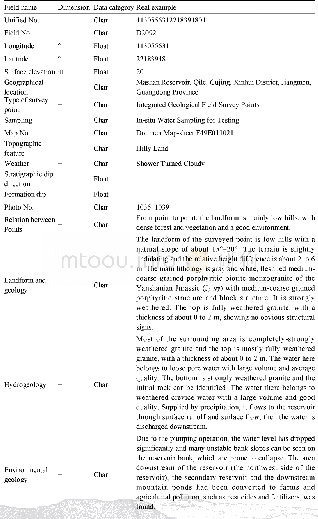
《Table 5 Table of Integrated Geological Field Survey》
 提示:宽带有限、当前游客访问压缩模式
本系列图表出处文件名:随高清版一同展现
《粤港澳湾区1:50000斗门镇幅工程地质调查及岩土样品试验数据集》
The data from the integrated geological field survey are presented in the table of integrated geological field survey,which includes:Unified No.,Field No.,Longitude,Latitude,Surface elevation,Geographical location,Type of survey point,Sampling,Map No.,Topographic feature,Weather,Stratigraphic dip direction,Formation dip,Photo No.,Relation between Points,Landform and geology,Hydrogeology,Environmental geology,Engineering geology,Visit and en-route,Artificial geological profile sketch(image),Survey point plan(image),Remark,Project name,Investigation entity,Investigator,Date of investigation,Recorder,Approver,Date of filling,etc.(Table 5).
| 图表编号 | XD00149451600 严禁用于非法目的 |
|---|---|
| 绘制时间 | 2019.12.01 |
| 作者 | 曾敏、赵信文、喻望、顾涛 |
| 绘制单位 | 中国地质调查局武汉地质调查中心、中国地质调查局武汉地质调查中心、中国地质调查局武汉地质调查中心、中国地质调查局武汉地质调查中心 |
| 更多格式 | 高清、无水印(增值服务) |
