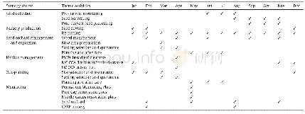
《Table AAnnual Activity Implementation Table for the Caicos Pine Restoration Strategy.PMPs-Permanent
 提示:宽带有限、当前游客访问压缩模式
本系列图表出处文件名:随高清版一同展现
《Conserving and restoring the Caicos pine forests: The first decade》
Core Conservation Areas(CCAs)for each pine forest on Middle Caicos,North Caicos and Pine Cay were identified by the project team in a workshop setting during the development of the restoration strategy for the Caicos pine forests using the GIS created and developed by the project team for TCI(Hamilton et al.,2016;Sanchez et al.,2016b).Three criteria were considered when identifying CCAs:a) public or privately-owned land that is not earmarked for development;b) land shows visible signs of potential resilience to sea-level rise(higher elevation or areas less likely to flood);and c) presence of living mature trees(regeneration potential).The North Caicos CCA is considerably larger than the remaining pine forest due to the large area of Crown Land on the island that previously supported pine forests.Table 1 shows the size and details for each CCA,while Fig.4 shows the location of the individual CCAs in the islands.
| 图表编号 | XD0063967600 严禁用于非法目的 |
|---|---|
| 绘制时间 | 2019.04.25 |
| 作者 | Michele Dani Sanchez、Bryan Naqqi Manco、Junel Blaise、Marcella Corcoran、Martin Allen Hamilton |
| 绘制单位 | The Herbarium, Royal Botanic Gardens、Department of Environment and Coastal Resources, National Environmental Centre、Department of Environment and Coastal Resources, National Environmental Centre、The Herbarium, Royal Botanic Gardens、The Herbarium, Royal Bo |
| 更多格式 | 高清、无水印(增值服务) |
