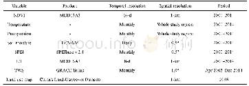
《Table 1 Datasets used in this study》
 提示:宽带有限、当前游客访问压缩模式
本系列图表出处文件名:随高清版一同展现
《Seasonal differences in climatic controls of vegetation growth in the Beijing–Tianjin Sand Source Region of China》
Note:NDVI,normalized difference vegetation index;SPEI,standardized precipitation evapotranspiration index;ET,evapotranspiration;TWS,total water storage;ECV-SM,essential climate variable-soil moisture;GRACE,Gravity Recovery and Climate Experiment.&apo
The main land use types with a spatial resolution of 1 km in the study region(Fig.1)were determined from the China's Land-Use/cover Datasets(CLUDs)obtained from the Resources and Environment Data Center,Chinese Academy of Sciences,China(Liu et al.,2014).The digital map of 2005 was used,as shown in Figure 1.
| 图表编号 | XD0020364300 严禁用于非法目的 |
|---|---|
| 绘制时间 | 2018.12.01 |
| 作者 | SHAN Lishan、YU Xiang、SUN Lingxiao、HE Bin、WANG Haiyan、XIE Tingting |
| 绘制单位 | College of Forestry, Gansu Agricultural University、Chinese Academy of Forestry、University of Chinese Academy of Sciences、College of Global Change and Earth System Science, Beijing Normal University、College of Global Change and Earth System Science, Beijin |
| 更多格式 | 高清、无水印(增值服务) |