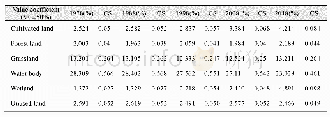
《Table 2 Land slope frequency distribution for different statistic units》
 提示:宽带有限、当前游客访问压缩模式
The slope frequency distribution is a quantitative analytical tool for slope analysis.However,slope accuracy de-pends on the DEM data.The ASTER GDEM v3.0 data were created from the automated processing of the entire ASTER Level 1A archive of scenes acquired between March 1,2000,and November 30,2013.The ASTER GDEM Version 3 data products offer a substantial improvement over Version 2 products.Although some relief changes during the data acquisition period,on a global scale the impact of these local topographic changes can be ignored.Figure 2 shows that Antarctica and Greenland have a high ground surface slope.Because ice and snow-covered areas have high optical reflectivity,a stereo correlation was used to produce the ASTER DEM.Therefore,DEM data in this area have poor quality and so do the slope frequency distribution data.We suggest that the slope frequency distribution data for Antarctica and Greenland in this data set be avoided in subsequent research.
| 图表编号 | XD00153326400 严禁用于非法目的 |
|---|---|
| 绘制时间 | 2020.03.25 |
| 作者 | 唐铃、马经纬、邵志燚、彭秋志 |
| 绘制单位 | 昆明理工大学国土资源工程学院、昆明理工大学国土资源工程学院、昆明理工大学国土资源工程学院、昆明理工大学国土资源工程学院、云南省高校高原山区空间信息测绘技术应用工程研究中心 |
| 更多格式 | 高清、无水印(增值服务) |


