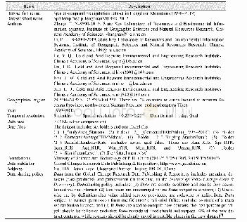
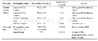
《Table 1 Metadatasummary for the“Spatial-temporal precipitation dataset inHengduan Mountains(1998–20
 提示:宽带有限、当前游客访问压缩模式
本系列图表出处文件名:随高清版一同展现
《横断山区降水时空分布数据集(1998–2012)》
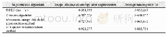
The Hengduan Mountains are controlled by variable atmospheric circulations,so the spatial and temporal distribution of precipitation varies greatly with the different months and seasons[10–11].The accuracy of the TRMM precipitation estimation in the Hengduan Mountains is also affected by the spatial and temporal precipitation distribution.The algorithm assumes that the same precipitation formation mechanism exists in the spatial units with more consistent spatial and temporal variations in the precipitation.Therefore,corrective models are established in the spatial units to reduce the impact of spatial and temporal variability in the precipitation for the correction model,thereby improving the accuracy of the estimation.The Hengduan Mountains are initially divided into several sub-regions with similar spatial distribution patterns for precipitation.The regression equation between the TRMM precipitation and ground measured precipitation is then established for each sub-region.Finally,the TRMM precipitation lattice values are revised based on the regression equation for each sub-region.
| 图表编号 | XD00110317200 严禁用于非法目的 |
|---|---|
| 绘制时间 | 2019.06.25 |
| 作者 | 张涛、李宝林、袁烨城、高锡章、蒋育昊、刘岩 |
| 绘制单位 | 中国科学院地理科学与资源研究所资源与环境信息系统国家重点实验室、中国科学院大学、中国科学院地理科学与资源研究所资源与环境信息系统国家重点实验室、中国科学院大学、中国科学院地理科学与资源研究所资源与环境信息系统国家重点实验室、中国科学院地理科学与资源研究所资源与环境信息系统国家重点实验室、中国科学院地理科学与资源研究所资源与环境信息系统国家重点实验室、中国科学院大学、中国科学院地理科学与资源研究所资源与环境信息系统国家重点实验室、中国科学院大学 |
| 更多格式 | 高清、无水印(增值服务) |