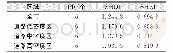
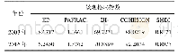
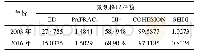
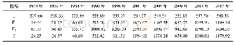
《表3 武汉市不同区域内景观格局指数表Tab.3 Landscape Pattern Index in Different Regions of Wuhan City》
 提示:宽带有限、当前游客访问压缩模式
本系列图表出处文件名:随高清版一同展现
《基于空间句法的不同道路密度区内土地利用特征研究——以武汉市为例》
武汉市全市及不同道路密度区内景观格局指数计算结果如表3所示。
| 图表编号 | XD008285800 严禁用于非法目的 |
|---|---|
| 绘制时间 | 2018.04.05 |
| 作者 | 宋丹阳、夏畅、王海军 |
| 绘制单位 | 武汉大学资源与环境科学学院、武汉大学资源与环境科学学院、武汉大学资源与环境科学学院 |
| 更多格式 | 高清、无水印(增值服务) |
